

General usage
Welcome to the Weather API! You can query our endpoints to be served different Numerical Weather Prediction (NWP) and reanalysis models in the format of your choice.
We have language bindings in Python! You can view code examples in the dark area to the right.
Authentication
To authenticate, use this code:
import requests

api_url = "https://api.rebase.energy/weather/v1/"
endpoint_url = api_url + endpoint
headers = {"Authorization": your_api_key}
response = requests.get(endpoint_url, headers=headers)
Make sure to replace
your_api_keywith the API key we provided you with, andendpointwith one valid endpoint.
Every request to the API needs to be authenticated with an API key.
The Weather API expects for the API key to be included in all API requests to the server in a header as follows:
Authorization: your_api_key
Common parameters
Example basic GET call:
import requests
import json

api_url = "https://api.rebase.energy/weather/v1/"
endpoint_url = api_url + endpoint
headers = {"Authorization": your_api_key}
params = {
    'model': 'DWD_ICON-EU',
    'coords': {'latitude': [60], 'longitude': [17]},
    'variables': ['T']
}
response = requests.get(endpoint_url, headers=headers, params={'query_params': json.dumps(params)})
Example basic POST call:
import requests

api_url = "https://api.rebase.energy/weather/v1/"
endpoint_url = api_url + endpoint
headers = {"Authorization": your_api_key}
params = {
    'model': 'DWD_ICON-EU',
    'coords': {'latitude': [60], 'longitude': [17]},
    'variables': ['T']
}
response = requests.post(endpoint_url,
                         headers=headers,
                         data={'query_params': params},
                         content_type='application/json')
The Weather API expects the following parameters for all endpoints:
| Parameter | Required | Description |
|---|---|---|
| model | Yes | Identifier of the dataset to query |
| coords | Yes | A JSON-like dictionary containing at least latitude and longitude as JSON-like lists of coordinates (latitude from -90 to 90, longitude from -180 to 180), and specific dimension slices if needed (refer to the desired model's dimension section) |
| variables | Yes | List of variable names, refer to each model's section to determine which ones are available |
| type | No | "grid" if you want to get all the (latitude, longitude) combinations from the provided latitude and longitude lists, "points" if you want to get only the ordered (latitude, longitude) pairs, default "grid" |
| output_format | No | Cf. related section. Possible values are "json_xarray", "json_pandas", "netcdf_url", default "json_xarray" |
Additional endpoint-specific parameters can be required, refer to endpoints' documentation.
Output formats
The API can return, as JSON data, pandas DataFrames, xarray Datasets or pre-signed URLS to NetCDF4 files.
pandas DataFrame
Example with pandas DataFrame:
import requests
import pandas as pd
import json

api_url = "https://api.rebase.energy/weather/v1/"
endpoint_url = api_url + endpoint
headers = {"Authorization": your_api_key}
params = {
    'model': 'DWD_ICON-EU',
    'coords': {'latitude': [60], 'longitude': [17]},
    'variables': ['T'],
    'output_format': 'json_pandas'
}
response = requests.get(endpoint_url, headers=headers, params={'query_params': json.dumps(params)})
df = pd.read_json(json.loads(response.text))

# # Optional: set clean index
# df.index = pd.MultiIndex.from_arrays(
#             [pd.to_datetime(df['ref_datetime'].values), pd.to_datetime(df['valid_datetime'].values)],
#             names=['ref_datetime', 'valid_datetime'])
# # Drop now duplicated index columns
# df = df.drop(columns=['ref_datetime', 'valid_datetime'])
Template of returned JSON:
{
    "ref_datetime": {
        "0": <ref_datetime_first_row>,
        "1": <ref_datetime_second_row>,
        ...},
    "valid_datetime": {
        "0": <valid_datetime_first_row>,
        "1": <valid_datetime_second_row>,
        ...},
    "<variable_1_name>_<dim_name>_<dim_value_1>_<lat_1>_<lon_1>": {
        "0": <value_first_row>,
        "1": <value_second_row>,
        ...},
    "<variable_1_name>_<dim_name>_<dim_value_1>_<lat_1>_<lon_2>": {
        "0": <value_first_row>,
        "1": <value_second_row>,
        ...},
    "<variable_1_name>_<dim_name>_<dim_value_1>_<lat_2>_<lon_1>": {
        "0": <value_first_row>,
        "1": <value_second_row>,
        ...},
    ...,
    "<variable_1_name>_<dim_name>_<dim_value_2>_<lat_1>_<lon_1>": {
        "0": <value_first_row>,
        "1": <value_second_row>,
        ...},
    ...,
    "<variable_2_name>_<dim_name>_<dim_value_1>_<lat_1>_<lon_1>": {
        "0": <value_first_row>,
        "1": <value_second_row>,
        ...},
    ...
}
Before being serialized to JSON, the DataFrame has a structure similar to the following:
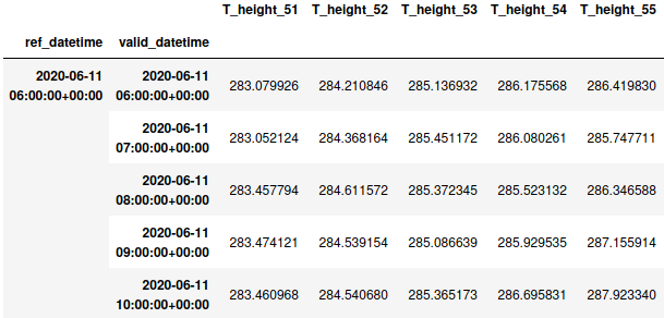
The different dimension values you query are flattened out in columns with the pattern [Variable_name]_[Dimension_name]_[Dimension_value].
The variables without dimensions are simply translated to one column with the name of the variable.
If you query multiple locations, the pattern gets extended to [Variable_name]_[Dimension_name]_[Dimension_value][Latitude_value][Longitude_value].
The index is a pandas MultiIndex of (reference_time, valid_time) tuples.
The structure of the JSON returned by the API is presented in the json tab of the right column.
xarray Dataset
Example with xarray Dataset:
import requests
import xarray as xr
import json

api_url = "https://api.rebase.energy/weather/v1/"
endpoint_url = api_url + endpoint
headers = {"Authorization": your_api_key}
params = {
    'model': 'DWD_ICON-EU',
    'coords': {'latitude': [60], 'longitude': [17]},
    'variables': ['T'],
    'output_format': 'json_xarray'
}
response = requests.get(endpoint_url, headers=headers, params={'query_params': json.dumps(params)})
ds = xr.Dataset.from_dict(json.loads(response.text))
Template of returned JSON:
{
    "attrs": {},
    "coords": {
        "coord_1": {
            "attrs": {},
            "data": [<coord_1 values>],
            "dims": [<coord_1 dimensions>]
        }, ...
    },
    "data_vars": {
        "variable_name": {
            "attrs": {},
            "data": [
                [ nesting depth depends on the number
                    [ of dimensions of the DataArray,
                        [ here 5 dimensions
                            [
                                <value>
                            ]
                        ],
                        [
                            [
                                <value>
                            ]
                        ], ...
                    ]
                ]
                    ],

            "dims": [
                        "reference_time",
                        "valid_time",
                        "height",
                        "latitude",
                        "longitude",
                        ...
                    ]

        }, ...
    },
    "dims": {
        "height": <no_height_slices>,
        "latitude": <no_latitude_points>,
        "longitude": <no_longitude_points>,
        "reference_time": <no_reference_times>,
        "valid_time": <length_forecast_horizon,
        ...
    }
}
Before being serialized to JSON, the Dataset has a structure similar to the following:
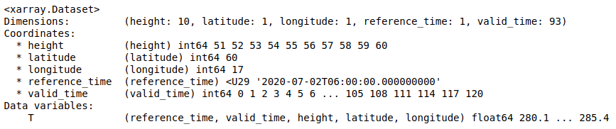
For more information about the elements of a xarray Dataset, please refer to xarray's data structures.
The structure of the JSON returned by the API is presented in the json tab of the right column.
URL to NetCDF4 file
Example with NetCDF4 url:
import requests
import json

api_url = "https://api.rebase.energy/weather/v1/"
endpoint_url = api_url + endpoint
headers = {"Authorization": your_api_key}
params = {
    'model': 'DWD_ICON-EU',
    'start_date': '2019-08-15 00',
    'end_date': '2019-08-20 00',
    'coords': {'latitude': [60], 'longitude': [17]},
    'variables': ['T'],
    'output_format': 'netcdf_url'
}
response = requests.get(endpoint_url, headers=headers, params={'query_params': json.dumps(params)})
netcdf_url = json.loads(response.text)['file']
Template of returned JSON:
{
    "create_time": <datetime_link_created>,
    "file": <pre-signed URL>
}
A pre-signed URL to the NetCDF file stored in a S3 bucket, that you can download with the mean of your choice, e.g. your web browser, a cURL command or simply a HTTP GET request. Recommended when the queried data starts to grow in size. Expires after one week.
Endpoints
get_latest_nwp
Returns the last model run from the requested model.
Example call for get_latest_nwp:
import requests
import json

endpoint_url = "https://api.rebase.energy/weather/v1/get_latest_nwp"
headers = {"Authorization": your_api_key}
params = {
    'model': 'DWD_ICON-EU',
    'coords': {'latitude': [60], 'longitude': [17], 'height': [59,60]},
    'variables': ['T', 'CLCT']
}
response = requests.get(endpoint_url, headers=headers, params={'query_params': json.dumps(params)})
get_nwp
Premium feature, request access
Returns a range of model runs from the requested model.
Requires the following parameters (cf. code examples in datasets section):
- ref_datetimes OR start_date, end_date, freq (optional): list of reference_datetimes (model run timestamps) that you want to get, or start and end date of the data you want to get, in format YYYY-MM-DD HH and UTC timezone, and optionally the frequency in hours between the model runs if you don't want all of them, in the format <freq>H
Example call for get_nwp:
import requests
import json

endpoint_url = "https://api.rebase.energy/weather/v1/get_nwp"
headers = {"Authorization": your_api_key}
params = {
    'model': 'DWD_ICON-EU',
    'coords': {'latitude': [60], 'longitude': [17], 'height': [59,60]},
    'variables': ['T', 'CLCT']
}
response = requests.get(endpoint_url, headers=headers, params={'query_params': json.dumps(params)})
Post-processed variables
Different datasets having different naming and unit conventions, we post-process some variables to make it easier for you to query several datasets at once. The post-processing transformations are explained in each datasets' variables section. The available post-process variables are the following:
| Name | Description | DWD-ICON-EU | DWD-ICON-D2 | NCEP-GFS | ECMWF-EPS_CF | ECMWF-HiRes | ECMWF-ERA5 | MetNo-MEPS | MetNo-HiRes | MeteoFrance-ARPEGE_EU | SMHI-MESAN | FMI-HIRLAM |
|---|---|---|---|---|---|---|---|---|---|---|---|---|
| Temperature | Temperature at 2m (°C) | ✔ | ✔ | ✔ | ✔ | ✔ | ✔ | ✔ | ✔ | ✔ | ✔ | ✔ |
| WindSpeed | Wind speed at 10m (m.s-1) | ✔ | ✔ | ✔ | ✔ | ✔ | ✔ | ✔ | ✔ | ✔ | ✔ | ✔ |
| WindDirection | Wind direction at 10m (°) | ✔ | ✔ | ✔ | ✔ | ✔ | ✔ | ✔ | ✔ | ✔ | ✔ | ✔ |
| CloudCover | Cloud cover fraction (0-1) | ✔ | ✔ | ✔ | ✔ | ✔ | ✔ | ✔ | ✔ | ✔ | ✔ | ✔ |
| RelativeHumidity | Relative humidity at 2m (%) | ✔ | ✔ | ✔ | ✔ | ✔ | ✔ | ✔ | ✔ | ✔ | ✔ | ✔ |
| PressureReducedMSL | Pressure at mean sea level (Pa) | ✔ | ✔ | ✔ | ✔ | ✔ | ✔ | ✔ | ✔ | ✔ | ✔ | ✔ |
| SolarDownwardRadiation | Surface solar radiation (W.m-2) | ✔ | ✖ | ✔ | ✔ | ✔ | ✔ | ✔ | ✔ | ✔ | ✖ | ✔ |
| TotalPrecipitation | Surface total precipitation (kg.m-2) | ✔ | ✔ | ✔ | ✔ | ✔ | ✔ | ✔ | ✔ | ✔ | ✔ | ✔ |
Datasets
ICON Europe (DWD), identifier: DWD_ICON-EU
Example call for DWD_ICON-EU:
import requests
import json

endpoint_url = "https://api.rebase.energy/weather/v1/get_nwp"
headers = {"Authorization": your_api_key}
params = {
    'model': 'DWD_ICON-EU',
    'start_date': '2019-08-15 00',
    'end_date': '2019-08-20 00',
    'coords': {'latitude': [60], 'longitude': [17], 'height': [59,60]},
    'variables': ['T', 'CLCT']
}
response = requests.get(endpoint_url, headers=headers, params={'query_params': json.dumps(params)})
Local nest over Europe of the ICOsahedral Nonhydrostatic model (ICON) developed jointly by Deutscher Wetterdienst (DWD) and the Max-Planck Institute for Meteorology in Hamburg (MPI-M) (documentation).
Geographical coverage and resolution: numbers, visualization
Time range and run times: from 2019-03-05 09:00 UTC to present. The model is ran every 3 hours (00, 03, 06, 09, 12, 15, 18, 21 UTC).
Forecast horizon and resolution: 5 days horizon for 00, 06, 12 and 18 runs: 79 steps with hourly resolution, 14 with 3-hourly resolution. 30 hours horizon for runs 03, 09, 15 and 21: 31 steps with hourly resolution.
Variables
| Name | Description |
|---|---|
| T | Temperature in Kelvin (K), at several heights (GRIB variable documentation) |
| U | Zonal wind in meters per second (m.s-1), at several heights (GRIB variable documentation) |
| V | Meridional wind in meters per second (m.s-1), at several heights (GRIB variable documentation) |
| CLCT | Total cloud cover in percents (%) (GRIB variable documentation) |
| CLCL | Low cloud cover (800hPa-Soil) in percents (%) (GRIB variable documentation) |
| CLCM | Medium cloud cover (400-800 hPa) in percents (%) (GRIB variable documentation) |
| CLCH | High cloud cover (0-400 hPa) in percents (%) (GRIB variable documentation) |
| ASOB_S | Net short wave radiation flux (m) (at the surface) in Watt per square meter (W.m-2). Only available from 2019-08-15 06:00:00 UTC onwards |
| ASWDIFD_S | Surface down solar diffuse radiation (average since model start) in Watt per square meter (W.m-2). Only available from 2019-08-15 06:00:00 UTC onwards |
| ASWDIR_S | Surface down solar diffuse radiation (average since model start) in Watt per square meter (W.m-2). Only available from 2019-08-15 06:00:00 UTC onwards |
| RELHUM_2M | Relative humidity in percents (%) at 2 meters above the surface (GRIB variable documentation). Only available from 2020-08-05 06:00:00 UTC onwards |
| PMSL | Pressure in Pascals (Pa) reduced to mean sea level(GRIB variable documentation). Only available from 2019-08-06 06:00:00 UTC onwards |
Post-processed variables
| Name | Description |
|---|---|
| Temperature | Temperature at 2m in degrees Celsius (°C) derived from Temperature |
| WindSpeed | Wind speed at 10m in meters per second (m.s-1) derived from U and V |
| WindDirection | Wind direction at 10m in degrees (°) derived from U and V |
| CloudCover | Cloud cover fraction (0-1) derived from CLCT |
| RelativeHumidity | Relative humidity at 2m in percents (%) derived from RELHUM_2M |
| PressureReducedMSL | Pressure at mean sea level pressure in Pascals (Pa) derived from PMSL |
| SolarDownwardRadiation | Surface solar radiation in Watts per square meter (W.m-2) derived from ASOB_S |
| TotalPrecipitation | Surface total precipitation (kg.m-2) derived from TOT_PREC |
Dimensions
| Name | Description |
|---|---|
| height | Height in meters, levels 51 to 60, cf. table |
| latitude | 29.5°N to 70.5°N with a resolution of ~0.0625° |
| longitude | -23.5°E to 45.0°E with a resolution of ~0.0625° |
ICON-D2 (DWD), identifier: DWD_ICON-D2
Example call for DWD_ICON-D2:
import requests
import json

endpoint_url = "https://api.rebase.energy/weather/v1/get_nwp"
headers = {"Authorization": your_api_key}
params = {
    'model': 'DWD_ICON-D2',
    'start_date': '2019-08-15 00',
    'end_date': '2019-08-20 00',
    'coords': {'latitude': [60], 'longitude': [17], 'height': [59,60]},
    'variables': ['T', 'CLCT']
}
response = requests.get(endpoint_url, headers=headers, params={'query_params': json.dumps(params)})
Local nest around Germany of the ICOsahedral Nonhydrostatic model (ICON) developed jointly by Deutscher Wetterdienst (DWD) and the Max-Planck Institute for Meteorology in Hamburg (MPI-M) (documentation).
Geographical coverage and resolution: visualization
Time range and run times: from 2020-08-01 00:00 UTC to present. The model is ran every 3 hours (00, 03, 06, 09, 12, 15, 18 and 21 UTC).
Forecast horizon and resolution: 48 hours horizon for all runs: 109 steps with 15 minutes resolution or 48 with hourly resolution, depending on the variable.
Variables
| Name | Description |
|---|---|
| T | Temperature in Kelvins (K) at different heights (GRIB variable documentation) |
| T_2M | Temperature in Kelvins (K) at 2 meters above the surface (GRIB variable documentation) |
| U | U-component of wind in meters per second (m.s-1) at different heights (GRIB variable documentation) |
| U_10M | U-component of wind in meters per second (m.s-1) at 10 meters above the surface (GRIB variable documentation) |
| V | V-component of wind in meters per second (m.s-1) at different heights (GRIB variable documentation) |
| V_10M | V-component of wind in meters per second (m.s-1) at 10 meters above the surface (GRIB variable documentation) |
| CLCT | Total cloud cover in percents (%) (GRIB variable documentation) |
| CLCL | Low cloud cover (800hPa-Soil) in percents (%) (GRIB variable documentation) |
| CLCM | Medium cloud cover (400-800 hPa) in percents (%) (GRIB variable documentation) |
| CLCH | High cloud cover (0-400 hPa) in percents (%) (GRIB variable documentation) |
| CLCT_MOD | Modified cloud cover for media (GRIB variable documentation) |
| CLC | Cloud cover in percents (%) at different heights (GRIB variable documentation) |
| RELHUM_2M | Relative humidity in percents (%) at 2 meters above the surface (GRIB variable documentation) |
| PMSL | Pressure in Pascals (Pa) reduced to mean sea level (GRIB variable documentation) |
| RAIN_GSP | Large-scale rain accumulation in kilos per square meter (kg.m-2) (GRIB variable documentation) |
| TOT_PREC | Total precipitation in kilograms per square meter (kg.m-2) (GRIB variable documentation) |
| RUNOFF_G | Soil water runoff (accumulated since model start) in kilos per square meter (kg.m-2) (GRIB variable documentation) |
| RUNOFF_S | Surface water runoff (accumulated since model start) in kilos per square meter (kg.m-2) (GRIB variable documentation) |
| RHO_SNOW | Snow density in kilos per cubic meter (kg.m-3) (GRIB variable documentation) |
| SNOWLMT | Height in meters (m) of snowfall limit above mean sea level (GRIB variable documentation) |
| SNOW_GSP | Large-scale snowfall accumulation |
| TKE | Turbulent kinetic energy in Joules per kilogram (J.kg-1) (GRIB variable documentation) |
| SOILTYP | Soil type (1-9) (GRIB variable documentation) |
| ROOTDP | Root depth in meters (m) of vegetation (GRIB variable documentation) |
Post-processed variables
| Name | Description |
|---|---|
| Temperature | Temperature at 2m in degrees Celsius (°C) derived from T |
| WindSpeed | Wind speed at 10m in meters per second (m.s-1) derived from U_10M and V_10M |
| WindDirection | Wind direction at 10m in degrees (°) derived from U_10M and V_10M |
| CloudCover | Cloud cover fraction (0-1) derived from CLCT |
| RelativeHumidity | Relative humidity at 2m in percents (%) derived from RELHUM_2M |
| PressureReducedMSL | Pressure at mean sea level in Pascals (Pa) derived from PMSL |
| TotalPrecipitation | Surface total precipitation (kg.m-2) derived from TOT_PREC |
Dimensions
| Name | Description |
|---|---|
| height | Height in meters, levels 56 to 65, cf. table |
| latitude | 43.0°N to 58.2°N with a resolution of ~2km |
| longitude | -4.15°E to 20.55°E with a resolution of ~2km |
HIRLAM (FMI), identifier: FMI_HIRLAM
Example call for FMI_HIRLAM:
import requests
import json

endpoint_url = "https://api.rebase.energy/weather/v1/get_nwp"
headers = {"Authorization": your_api_key}
params = {
    'model': 'FMI_HIRLAM',
    'start_date': '2019-08-15 00',
    'end_date': '2019-08-20 00',
    'coords': {'latitude': [60], 'longitude': [17]},
    'variables': ['Temperature', 'WindSpeed', 'WindDirection']
}
response = requests.get(endpoint_url, headers=headers, params={'query_params': json.dumps(params)})
High Resolution Limited Area Model (HIRLAM) developed by the international HIRLAM programme and ran by the Finnish Meteorological Institute (FMI) (documentation).
Geographical coverage and resolution: latitudes 25.65 to 90°N, longitudes -180 to 180°E, 7.5 kilometers resolution visualization
Time range and run times: from 2019-01-01 00:00:00 UTC to present. The model is ran four times a day with analysis hours 00, 06, 12 and 18.
Forecast horizon and resolution: 54 hours horizon for all runs: 55 steps with hourly resolution.
Variables
| Name | Description |
|---|---|
| Temperature_2m | Temperature of air in Kelvin (K) at 2m (GRIB variable documentation) |
| WindUMS | Horizontal speed of air moving towards the east, in metres per second (m.s-1), at 10m (GRIB variable documentation) |
| WindVMS | Horizontal speed of air moving towards the north, in metres per second (m.s-1), at 10m (GRIB variable documentation) |
| TotalCloudCover | Total cloud cover proportion (0-1) (GRIB variable documentation) |
| LowCloudCover | Low (surface pressure to 0.8*surface pressure) cloud cover proportion (0-1) (GRIB variable documentation) |
| MediumCloudCover | Medium (0.8*surface pressure to 0.45*surface pressure) cloud cover proportion (0-1) (GRIB variable documentation) |
| HighCloudCover | High (0.45*surface pressure to 0hPa) cloud cover proportion (0-1) (GRIB variable documentation) |
| RadiationGlobalAccumulation | Surface solar radiation downwards in Joule per square meter (J.m-2)(GRIB variable documentation). Only available from 2019-03-30 00:00:00 UTC onwards |
| Humidity | |
| GeopHeight | |
| WindGust | |
| PrecipitationAmount | |
| Precipitation1h | |
| LowCloudCover | |
| MediumCloudCover | |
| HighCloudCover | |
| Pressure |
Post-processed variables
| Name | Description |
|---|---|
| Temperature | Temperature at 2m in degrees Celsius (°C) derived from Temperature_2m |
| WindSpeed | Wind speed at 10m in meters per second (m.s-1) derived from WindUMS and WindVMS |
| WindDirection | Wind direction at 10m in degrees (°) derived from WindUMS and WindVMS |
| CloudCover | Cloud cover fraction (0-1) derived from TotalCloudCover |
| SolarDownwardRadiation | Surface solar radiation in Watts per square meter (W.m-2) derived from RadiationGlobalAccumulation |
| RelativeHumidity | Relative humidity at 2m in percents derived from Humidity (%) |
| PressureReducedMSL | Pressure at mean sea level in Pascals (Pa) derived from Pressure |
| TotalPrecipitation | Surface total precipitation (kg.m-2) derived from PrecipitationAmount |
Dimensions
| Name | Description |
|---|---|
| latitude | 25.65°N to 90.0°N with a resolution of ~0.0680° |
| longitude | -180°E to 180°E with a resolution of ~0.0680° |
GFS (NCEP), identifier: NCEP_GFS
Example call for NCEP_GFS:
import requests
import json

endpoint_url = "https://api.rebase.energy/weather/v1/get_nwp"
headers = {"Authorization": your_api_key}
params = {
    'model': 'NCEP_GFS',
    'start_date': '2019-08-15 00',
    'end_date': '2019-08-20 00',
    'coords': {'latitude': [60], 'longitude': [17], 'lv_HTGL2': [2.0,80.0], 'lv_ISBL7': [95000.0, 100000.0]},
    'variables': ['Temperature_Height', 'CloudCover_Isobar']
}
response = requests.get(endpoint_url, headers=headers, params={'query_params': json.dumps(params)})
Global Forecast System (GFS) produced by the National Centers for Environmental Prediction (NCEP) (general documentation, scientific documentation).
Geographical coverage and resolution: global coverage wih 0.25 latitude and longitude resolution
Time range and run times: from 2019-06-24 06:00 UTC to present. The model is ran every 6 hours (00, 06, 12, 18 UTC).
Forecast horizon and resolution: 16 days horizon for all runs: 121 steps with hourly resolution, 88 with 3 hours resolution.
Variables
| Name | Description |
|---|---|
| WindGust | Wind speed (gust) in meters per second (m.s-1) (GRIB variable documentation). Only available from 2019-09-02 06:00:00 UTC onwards |
| WindUMS_Height | U-component of wind in meters per second (m.s-1), at several heights (lv_HTGL8) (GRIB variable documentation) |
| WindVMS_Height | V-component of wind in meters per second (m.s-1), at several heights (lv_HTGL8) (GRIB variable documentation) |
| WindUMS_Isobar | U-component of wind in meters per second (m.s-1), at several isobaric heights (lv_ISBL5) (GRIB variable documentation). Only available from 2019-09-02 06:00:00 UTC onwards |
| WindVMS_Isobar | V-component of wind in meters per second (m.s-1), at several isobaric heights (lv_ISBL5) (GRIB variable documentation). Only available from 2019-09-02 06:00:00 UTC onwards |
| StormMotionU_Height | U-component storm motion, in meters per second (m.s-1) (GRIB variable documentation). Only available from 2019-09-02 06:00:00 UTC onwards |
| StormMotionV_Height | V-component storm motion, in meters per second (m.s-1) (GRIB variable documentation). Only available from 2019-09-02 06:00:00 UTC onwards |
| StormRelativeHelicity_Height | Storm relative helicity in square meters per square seconds (m2.s-2) (GRIB variable documentation). Only available from 2019-09-02 06:00:00 UTC onwards |
| SurfacePressure | Pressure at surface level in Pascal (Pa) (GRIB variable documentation) |
| PressureReducedMSL | Pressure at mean sea level in Pascal (Pa) (GRIB variable documentation). Only available from 2020-03-04 00:00:00 UTC onwards |
| RelativeHumidity_Isobar | Relative humidity in percents (%), at several isobaric heights (lv_ISBL5) (GRIB variable documentation). Only available from 2019-09-02 06:00:00 UTC onwards |
| RelativeHumidity_Height | Relative humidity in percents (%) (GRIB variable documentation) |
| PrecipitableWater | Precipitable water in kilos per square meters (kg.m-2) (GRIB variable documentation). Only available from 2020-03-04 00:00:00 UTC onwards |
| SurfacePrecipitationRate | Precipitation rate at the surface in kilos per square meters per seconds (kg.m-2.s-1) (GRIB variable documentation). Only available from 2020-03-04 00:00:00 UTC onwards |
| SurfacePrecipitationRateAvg | Average precipitation rate at the surface in kilos per square meters per seconds (kg.m-2.s-1) (GRIB variable documentation). Only available from 2020-03-04 00:00:00 UTC onwards |
| SurfaceTotalPrecipitation | Accumulated total precipitation at the surface in kilos per square meters (kg.m-2) (GRIB variable documentation). Only available from 2020-03-04 00:00:00 UTC onwards |
| SurfaceSnowDepth | Snow depth at the surface in meters (m) (GRIB variable documentation). Only available from 2020-03-04 00:00:00 UTC onwards |
| SurfaceWaterEqAccSnowDepth | Water equivalent of accumulated snow depth at the surface in kilos per square meters (kg.m-2) (GRIB variable documentation). Only available from 2020-03-04 00:00:00 UTC onwards |
| Temperature_Height | Temperature in Kelvin (K), at several heights (lv_HTGL2) (GRIB variable documentation) |
| PotentialTemperature_Sigma | Potential temperature in Kelvin (K) (GRIB variable documentation). Only available from 2019-09-02 06:00:00 UTC onwards |
| SoilMoisture_Depth | Volumetric soil moisture content in fraction, at several depths (lv_DBLL14) (GRIB variable documentation). Only available from 2019-09-02 06:00:00 UTC onwards |
| SoilTemperature_Depth | Soil temperature in Kelvin (K), at several depths (lv_DBLL14) (GRIB variable documentation). Only available from 2019-09-02 06:00:00 UTC onwards |
| PlanetaryBoundaryLayer_Height | Planetary boundary layer height in meters (m) (GRIB variable documentation). Only available from 2019-09-02 06:00:00 UTC onwards |
| CloudCover_Isobar | Total cloud cover in percent (%), at several isobaric heights (lv_ISBL7) (GRIB variable documentation) |
| SurfaceRadiationShortWaveDownAvg | Average downward short-wave radiation flux in Watts per square meters (W.m-2) (GRIB variable documentation). Only available from 2019-09-02 06:00:00 UTC onwards |
| SurfaceRadiationShortWaveUpAvg | Average upward long-wave radiation flux in Watts per square meters (W.m-2) (GRIB variable documentation). Only available from 2019-09-02 06:00:00 UTC onwards |
| SurfaceRadiationLongWaveDownAvg | Average downward long-wave radiation flux in Watts per square meters (W.m-2) (GRIB variable documentation). Only available from 2019-09-02 06:00:00 UTC onwards |
| SurfaceLatentHeatNetFluxAvg | Average latent heat net flux at the surface in Watts per square meters (W.m-2) (GRIB variable documentation). Only available from 2020-03-04 00:00:00 UTC onwards |
| SurfaceSensibleHeatNetFluxAvg | Average sensible heat net flux at the surface in Watts per square meters (W.m-2) (GRIB variable documentation). Only available from 2020-03-04 00:00:00 UTC onwards |
Post-processed variables
| Name | Description |
|---|---|
| Temperature | Temperature at 2m in degrees Celsius (°C) derived from Temperature_Height |
| WindSpeed | Wind speed at 10m in meters per second (m.s-1) derived from WindUMS_Height and WindVMS_Height |
| WindDirection | Wind direction at 10m in degrees (°) derived from WindUMS_Height and WindVMS_Height |
| CloudCover | Cloud cover fraction (0-1) derived from CloudCover_Isobar |
| RelativeHumidity | Relative humidity at 2m in percents (%) derived from RelativeHumidity_Height |
| PressureReducedMSL | Pressure at mean sea level in Pascals (Pa) derived from PressureReducedMSL |
| SolarDownwardRadiation | Surface solar radiation in Watts per square meter (W.m-2) derived from SurfaceRadiationShortWaveDownAvg |
| TotalPrecipitation | Surface total precipitation (kg.m-2) derived from SurfaceTotalPrecipitation |
Dimensions
| Name | Description |
|---|---|
| lv_HTGL2 | Height in meters in the ensemble {2.0; 80.0; 100.0} |
| lv_HTGL8 | Height in meters in the ensemble {10.0; 20.0; 30.0; 40.0; 50.0; 80.0; 100.0} |
| lv_ISBL5 | Isobaric surfaces in Pascals in the ensemble {90000.0; 92500.0} (explanation of constant pressure surfaces). |
| lv_ISBL7 | Isobaric surfaces in Pascals in the ensemble {5000.0; 10000.0; 15000.0; 20000.0; 25000.0; 30000.0; 35000.0; 40000.0; 45000.0; 50000.0; 55000.0; 60000.0; 65000.0; 70000.0; 75000.0; 80000.0; 85000.0; 90000.0; 92500.0; 95000.0; 97500.0; 100000.0} (explanation of constant pressure surfaces) |
| lv_DBLL14 | Depth layers in the ensemble {0; 1; 2; 3}, respectively corresponding to {[0-0.1]; [0.1-0.4]; [0.4-1]; [1-2]} meters below ground |
| latitude | -90.0°N to 90.0°N with a resolution of ~0.25° |
| longitude | 0.0°E to 359.75°E with a resolution of ~0.25° |
MEPS (MetNo), identifier: MetNo_MEPS
Example call for MetNo_MEPS:
import requests
import json

endpoint_url = "https://api.rebase.energy/weather/v1/get_nwp"
headers = {"Authorization": your_api_key}
params = {
    'model': 'MetNo_MEPS',
    'start_date': '2019-08-15 00',
    'end_date': '2019-08-20 00',
    'coords': {'latitude': [60], 'longitude': [17], 'height2': [80.0]},
    'variables': ['air_temperature_z', 'relative_humidity_z']
}
response = requests.get(endpoint_url, headers=headers, params={'query_params': json.dumps(params)})
MEPS (The MetCoOp Ensemble Prediction System) is a 10-member short-range convection permitting ensemble prediction system produced by MetCoOp, the Meterological Cooperation on Operational Numeric Weather Prediction (NWP) between Finnish Meteorological Institute (FMI), MET Norway and Swedish Meteorological and Hydrological Institute (SMHI) (documentation). The data available through the Weather API corresponds to the first ensemble, the control run, which is not perturbed.
Geographical coverage and resolution: latitudes 49.75 to 75.20°N, longitudes -18.15 to 54.20°E (interactive)
Time range and run times: from 2018-01-01 00:00 UTC to present. The model is ran every 6 hours (00, 06, 12, 18 UTC).
Forecast horizon and resolution: 66 hours horizon for all runs: 67 steps with hourly resolution.
Variables
| Name | Description |
|---|---|
| x_wind_10m | U-component of wind in meters per second (m.s-1) at 10 meters above ground (GRIB variable documentation) |
| y_wind_10m | V-component of wind in meters per second (m.s-1) at 10 meters above ground (GRIB variable documentation) |
| x_wind_z | U-component of wind in meters per second (m.s-1), at several heights (height2) (GRIB variable documentation) |
| y_wind_z | V-component of wind in meters per second (m.s-1), at several heights (height2) (GRIB variable documentation) |
| air_pressure_at_sea_level | Mean sea level pressure in Pascal (Pa) (GRIB variable documentation) |
| air_temperature_0m | Surface air temperature in Kelvin (K) (GRIB variable documentation) |
| air_temperature_2m | Air temperature in Kelvin (K) at 2 meters above ground (GRIB variable documentation) |
| air_temperature_z | Air temperature in Kelvin (K), at several heights (height2) (GRIB variable documentation) |
| relative_humidity_2m | Relative humidity in proportion (0-1) at 2 meters above ground |
| relative_humidity_z | Relative humidity in proportion (0-1) at several heights (height2) |
| cloud_area_fraction | Total cloud cover in proportion (0-1) (GRIB variable documentation) |
| low_type_cloud_area_fraction | Low cloud cover in proportion (0-1) |
| medium_type_cloud_area_fraction | Medium cloud cover in proportion (0-1) |
| high_type_cloud_area_fraction | High cloud cover in proportion (0-1) |
| integral_of_rainfall_amount_wrt_time | Accumulated rainfall at surface in kilograms per square meters (kg.m-2) |
| integral_of_surface_net_downward _shortwave_flux_wrt_time |
Accumulated net downward surface short-wave radiation in Watts second per square meters (W.s.m-2) |
| symbols | String describing the weather conditions (list of possible values) |
Post-processed variables
| Name | Description |
|---|---|
| Temperature | Temperature at 2m in degrees Celsius (°C) derived from air_temperature_2m |
| WindSpeed | Wind speed at 10m in meters per second (m.s-1) derived from x_wind_10m and y_wind_10m |
| WindDirection | Wind direction at 10m in degrees (°) derived from x_wind_10m and y_wind_10m |
| CloudCover | Cloud cover fraction (0-1) derived from cloud_area_fraction |
| RelativeHumidity | Relative humidity at 2m in percents (%) derived from relative_humidity_2m |
| PressureReducedMSL | Pressure at mean sea level in Pascals (Pa) derived from air_pressure_at_sea_level |
| SolarDownwardRadiation | Surface solar radiation in Watts per square meter (W.m-2) derived from integral_of_surface_net_downward _shortwave_flux_wrt_time |
| TotalPrecipitation | Surface total precipitation (kg.m-2) derived from integral_of_rainfall_amount_wrt_time |
Dimensions
| Name | Description |
|---|---|
| height2 | Height in meters in the ensemble {80.0; 100.0} |
| latitude | 49.75 to 75.20°N with a resolution of ~0.1° |
| longitude | -18.15 to 54.20°E with a resolution of ~0.4° |
MEPS High Resolution (MetNo), identifier: MetNo_HIRESMEPS
Example call for MetNo_HIRESMEPS:
import requests
import json

endpoint_url = "https://api.rebase.energy/weather/v1/get_nwp"
headers = {"Authorization": your_api_key}
params = {
    'model': 'MetNo_HIRESMEPS',
    'start_date': '2019-08-15 00',
    'end_date': '2019-08-20 00',
    'coords': {'latitude': [60], 'longitude': [17]},
    'variables': ['air_temperature_2m', 'relative_humidity_2m']
}
response = requests.get(endpoint_url, headers=headers, params={'query_params': json.dumps(params)})
MEPS (The MetCoOp Ensemble Prediction System) is a 10-member short-range convection permitting ensemble prediction system produced by MetCoOp, the Meterological Cooperation on Operational Numeric Weather Prediction (NWP) between Finnish Meteorological Institute (FMI), MET Norway and Swedish Meteorological and Hydrological Institute (SMHI) (documentation). The data available through the Weather API corresponds to a subset of the first ensemble, the control run, which is not perturbed.
Geographical coverage and resolution: latitudes 52.3 to 73.8°N, longitudes -11.8 to 41.7°E (interactive)
Time range and run times: from 2020-03-02 14:00 UTC to present. The model is ran every hour.
Forecast horizon and resolution: between 56 and 58 hours for all runs: 57 to 59 steps with hourly resolution.
Variables
| Name | Description |
|---|---|
| air_pressure_at_sea_level | Mean sea level pressure in Pascal (Pa) (GRIB variable documentation) |
| air_temperature_2m | Air temperature in Kelvin (K) at 2 meters above ground (GRIB variable documentation) |
| relative_humidity_2m | Relative humidity in proportion (0-1) at 2 meters above ground |
| cloud_area_fraction | Total cloud cover in proportion (0-1) (GRIB variable documentation) |
| altitude | Surface altitude in meters (m) |
| wind_direction_10m | Wind direction in degrees (∈[0;360])(°) at 10 meters above ground |
| wind_speed_10m | Wind speed in meters per second (m.s-1) at 10 meters above ground |
| wind_speed_of_gust | Wind speed of gust in meters per second (m.s-1) |
| integral_of_surface_downwelling _shortwave_flux_in_air_wrt_time |
Integral of surface downwelling short-wave flux in air with respect to time in Watts second per square meter (W.s.m-2) |
| land_area_fraction | Proportion (0-1) of land in the grid box(GRIB variable documentation) |
| precipitation_amount | Precipitation amount in kilograms per square meter (kg.m-2) |
| symbols | String describing the weather conditions (list of possible values) |
Post-processed variables
| Name | Description |
|---|---|
| Temperature | Temperature at 2m in degrees Celsius (°C) derived from air_temperature_2m |
| WindSpeed | Wind speed at 10m in meters per second (m.s-1) derived from wind_speed_10m |
| WindDirection | Wind direction at 10m in degrees (°) derived from wind_direction_10m |
| CloudCover | Cloud cover fraction (0-1) derived from cloud_area_fraction |
| RelativeHumidity | Relative humidity at 2m in percents (%) derived from relative_humidity_2m |
| PressureReducedMSL | Pressure at mean sea level in Pascals (Pa) derived from air_pressure_at_sea_level |
| SolarDownwardRadiation | Surface solar radiation in Watts per square meter (W.m-2) derived from integral_of_surface_downwelling _shortwave_flux_in_air_wrt_time |
| TotalPrecipitation | Surface total precipitation (kg.m-2) derived from precipitation_amount |
Dimensions
| Name | Description |
|---|---|
| latitude | 52.3 to 73.8°N with a resolution of ~0.0036° |
| longitude | -11.8 to 41.7°E with a resolution of ~0.0117° |
ARPEGE Europe (Meteo France), identifier: MeteoFrance_ARPEGE-EU
Example call for MeteoFrance_ARPEGE-EU:
import requests
import json

endpoint_url = "https://api.rebase.energy/weather/v1/get_nwp"
headers = {"Authorization": your_api_key}
params = {
    'model': 'MeteoFrance_ARPEGE-EU',
    'start_date': '2020-03-25 00',
    'end_date': '2020-04-01 00',
    'coords': {'latitude': [60], 'longitude': [17], 'lv_HTGL0': [20,35]},
    'variables': ['WindSpeed_height', 'SurfaceTotalCloudCover']
}
response = requests.get(endpoint_url, headers=headers, params={'query_params': json.dumps(params)})
Local nest over Europe of the global numerical weather prediction model ARPEGE (Action de Recherche Petite Echelle Grande Echelle) provided by Météo France (general documentation, scientific documentation).
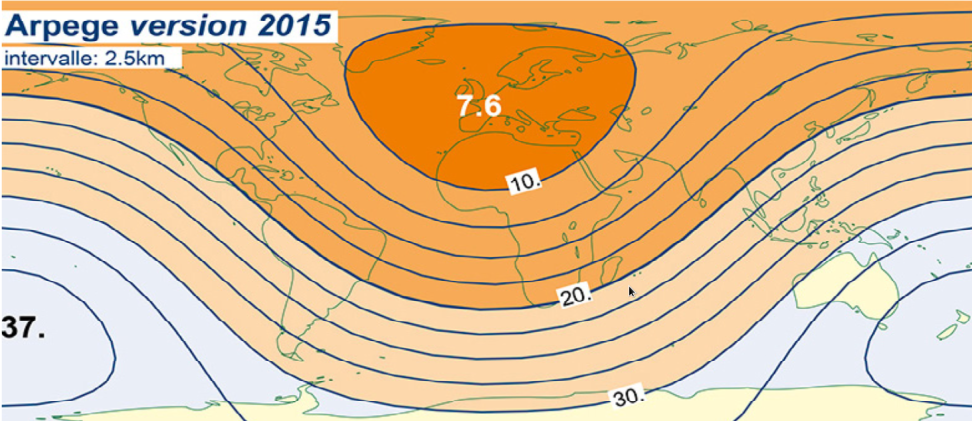
Geographical coverage and resolution: latitudes 20.0 to 72.0°N, longitudes -32.0 to 42.0°E with 0.1° step in both directions visualisation
Time range and run times: from 2020-03-18 06:00 UTC to present. The model is ran every 6 hours (00, 06, 12, 18 UTC).
Forecast horizon and resolution: 114 hours horizon for run 12: 115 steps with hourly resolution. 102 hours horizon for run 00: 103 steps with hourly resolution. 72 hours horizon for run 06: 73 steps with hourly resolution. 60 hours horizon for run 18: 61 steps with hourly resolution.
Variables
| Name | Description |
|---|---|
| DownwardLongWaveRadiationFluxAvg | Average downward long wave radiation flux in Watts per square meter (W.m-2) at the surface (GRIB variable documentation) |
| HighCloudCover | High cloud cover in percents (%) at the surface (GRIB variable documentation) |
| LowCloudCover | Low cloud cover in percents (%) at the surface (GRIB variable documentation) |
| MediumCloudCover | Medium cloud cover in percents (%) at the surface (GRIB variable documentation) |
| PressureMSL | Mean sea level pressure in Pascals (Pa) (GRIB variable documentation) |
| SnowMeltAvg | Average snow melt in kilos per square meter (kg.m-2) at the surface (GRIB variable documentation) |
| SurfaceDewPointTemperature | Dew point temperature in Kelvins (K) at 2 meters above ground (GRIB variable documentation) |
| SurfaceDownwardShortWaveRadiationFluxAvg | Average downward short wave radiation flux in Watts per square meter (W.m-2) at the surface (GRIB variable documentation) |
| SurfaceRelativeHumidity | Relative humidity in percents (%) at 2 meters above ground (GRIB variable documentation) |
| SurfaceSpecificHumidity | Specific humidity in kilos per kilo (kg.kg-1) at 2 meters above ground (GRIB variable documentation) |
| SurfaceTotalCloudCover | Total cloud cover in percents (%) at the surface (GRIB variable documentation) |
| SurfaceWindDirection | Direction from which the wind blows in degrees true (°) at 10 meters above ground (GRIB variable documentation) |
| SurfaceWindSpeed | Wind speed in meters per second (m.s-1) at 10 meters above ground (GRIB variable documentation) |
| SurfaceWindSpeedGust | Wind speed (gust) in meters per second (m.s-1) at 10 meters above ground (GRIB variable documentation) |
| SurfaceWindU | U-component of wind in meters per second (m.s-1) at 10 meters above ground (GRIB variable documentation) |
| SurfaceWindUGust | U-component of wind speed (gust) in meters per second (m.s-1) at 10 meters above ground (GRIB variable documentation) |
| SurfaceWindV | V-component of wind in meters per second (m.s-1) at 10 meters above ground (GRIB variable documentation) |
| SurfaceWindVGust | V-component of wind speed (gust) in meters per second (m.s-1) at 10 meters above ground (GRIB variable documentation) |
| Temperature2m | Temperature in Kelvin (K) at 2 meters above ground (GRIB variable documentation) |
| TotalPrecipitationRateAcc | Accumulated (since reference time) total precipitation rate at the surface in kilos per square meter per second (kg.m-2.s-1) (GRIB variable documentation) |
| WindDirection_Height | Direction from which the wind blows in degrees true (°) at different heights (GRIB variable documentation) |
| WindSpeed_height | Wind speed in meters per second (m.s-1) at different heights (GRIB variable documentation) |
| WindU_Height | U-component of wind in meters per second (m.s-1) at different heights (GRIB variable documentation) |
| WindV_Height | V-component of wind in meters per second (m.s-1) at different heights (GRIB variable documentation) |
Post-processed variables
| Name | Description |
|---|---|
| Temperature | Temperature at 2m in degrees Celsius (°C) derived from Temperature2m |
| WindSpeed | Wind speed at 10m in meters per second (m.s-1) derived from SurfaceWindSpeed |
| WindDirection | Wind direction at 10m in degrees (°) derived from SurfaceWindDirection |
| CloudCover | Cloud cover fraction (0-1) derived from SurfaceTotalCloudCover |
| RelativeHumidity | Relative humidity at 2m in percents (%) derived from SurfaceRelativeHumidity |
| PressureReducedMSL | Pressure at mean sea level in Pascals (Pa) derived from PressureMSL |
| SolarDownwardRadiation | Surface solar radiation in Watts per square meter (W.m-2) derived from SurfaceDownwardShortWaveRadiationFluxAvg |
| TotalPrecipitation | Surface total precipitation (kg.m-2) derived from TotalPrecipitationRateAcc |
Dimensions
| Name | Description |
|---|---|
| lv_HTGL0 | Height in meters in the ensemble {20, 35, 50, 75, 100, 150, 200, 250, 375, 500, 625, 750, 875, 1000, 1125, 1250, 1375, 1500, 1750, 2000, 2250, 2500, 2750, 3000} |
| latitude | 20.0°N to 72.0°N with a resolution of ~0.1° |
| longitude | -32.0°E to 42.0°E with a resolution of ~0.1° |
ERA5 (ECMWF), identifier: ECMWF_ERA5
Example call for ECMWF_ERA5:
import requests
import json

endpoint_url = "https://api.rebase.energy/weather/v1/get_nwp"
headers = {"Authorization": your_api_key}
params = {
    'model': 'ECMWF_ERA5',
    'start_date': '2019-01-01 00',
    'end_date': '2019-01-15 00',
    'coords': {'latitude': [60], 'longitude': [17]},
    'variables': ['t2m', 'msl']
}
response = requests.get(endpoint_url, headers=headers, params={'query_params': json.dumps(params)})
ERA5 (ECMWF ReAnalysis 5) is the fifth generation atmospheric reanalysis of the global climate provided by ECMWF (documentation). Reanalysis combines model data with observations from across the world into a globally complete and consistent dataset using the laws of physics.
Geographical coverage and resolution: global coverage with 0.25° resolution.
Time range and resolution: from 1979-01-01 00:00 UTC to last month's last hour, with a time resolution of 1 hour.
Variables
| Name | Description |
|---|---|
| msl | Air pressure at mean sea level in Pascals (Pa) (GRIB variable documentation) |
| t2m | Temperature in Kelvins (K) at 2 meters above the surface (GRIB variable documentation) |
| mx2t | Maximum temperature since previous post-processing in Kelvins (K) at 2 meters above the surface (GRIB variable documentation) |
| mn2t | Minimum temperature since previous post-processing in Kelvins (K) at 2 meters above the surface (GRIB variable documentation) |
| d2m | Dew point temperature in Kelvins (K) at 2 meters above the surface (GRIB variable documentation) |
| u100 | U-component of wind in meters per second (m.s-1) at 100 meters above the surface (GRIB variable documentation) |
| u10 | U-component of wind in meters per second (m.s-1) at 10 meters above the surface (GRIB variable documentation) |
| ssrd | Surface solar radiation downwards in Joules per square meter (J.m-2) (GRIB variable documentation) |
| sd | Snow depth at the surface in meters of water equivalent (GRIB variable documentation) |
| v100 | V-component of wind in meters per second (m.s-1) at 100 meters above the surface (GRIB variable documentation) |
| v10 | V-component of wind in meters per second (m.s-1) at 10 meters above the surface (GRIB variable documentation) |
| tp | Total precipitation in meters (GRIB variable documentation) |
| rsn | Snow density in kilograms per cubic meter (kg.m-3) (GRIB variable documentation) |
| sp | Air pressure in Pascals (Pa) at the surface (GRIB variable documentation) |
| tcc | Total cloud cover in fraction (0-1) (GRIB variable documentation) |
| hcc | High cloud cover in fraction (0-1) (GRIB variable documentation) |
| mcc | Medium cloud cover in fraction (0-1) (GRIB variable documentation) |
| lcc | Low cloud cover in fraction (0-1) (GRIB variable documentation) |
| ssr | Surface net solar radiation in Joules per square meter (J.m-2) (GRIB variable documentation) |
| lspf | Large-scale precipitation fraction in seconds (s) (GRIB variable documentation) |
| i10fg | Instantaneous 10 metres wind gust in meters per second (m.s-1) (GRIB variable documentation) |
Post-processed variables
| Name | Description |
|---|---|
| Temperature | Temperature at 2m in degrees Celsius (°C) derived from t2m |
| WindSpeed | Wind speed at 10m in meters per second (m.s-1) derived from u10 and v10 |
| WindDirection | Wind direction at 10m in degrees (°) derived from u10 and v10 |
| CloudCover | Cloud cover fraction (0-1) derived from tcc |
| RelativeHumidity | Relative humidity at 2m in percents (%) derived from t2m and d2m |
| PressureReducedMSL | Pressure at mean sea level pressure in Pascals (Pa) derived from msl |
| SolarDownwardRadiation | Surface solar radiation in Watts per square meter (W.m-2) derived from ssr |
| TotalPrecipitation | Surface total precipitation (kg.m-2) derived from tp |
Dimensions
| Name | Description |
|---|---|
| latitude | -90.0°N to 90.0°N of ~0.25° |
| longitude | 0.0°E to 359.75°E with a resolution of ~0.25° |
MESAN (SMHI), identifier: SMHI_MESAN
Example call for SMHI_MESAN:
import requests
import json

endpoint_url = "https://api.rebase.energy/weather/v1/get_nwp"
headers = {"Authorization": your_api_key}
params = {
    'model': 'SMHI_MESAN',
    'start_date': '2019-01-01 00',
    'end_date': '2019-01-15 00',
    'coords': {'latitude': [60], 'longitude': [17]},
    'variables': ['udvwgrd', 'asngrd']
}
response = requests.get(endpoint_url, headers=headers, params={'query_params': json.dumps(params)})
MESAN is a meteorological reanalysis model provided by SMHI that describes the current weather conditions in grid tiles (documentation). The model also serves as a complement to observations as the number of measuring stations is limited.
Geographical coverage and resolution: latitudes 52.4 to 72.6°N, longitudes -9.6 to 39.2 with 0.1° step in both directions visualisation.
Time range and resolution: from 2014-12-04 00:00 UTC to present, with a time resolution of 1 hour.
Variables
| Name | Description |
|---|---|
| asngrd | Wind gusts in meters per second (m.s-1) at the surface |
| bldgrd | Type of precipitation in codes ({-9.; 1.}) |
| c_sigfr | Fraction of significant clouds (0-1) |
| grd2t | 3 hours precipitation in millimeters (mm) |
| hcc | High cloud cover in fraction (0-1) |
| lcc | Low cloud cover in fraction (0-1) |
| mcc | Medium cloud cover in fraction (0-1) |
| mn2t24grd | Relative humidity in percents (%) at the surface |
| p71.129 | Total cloud cover in fraction (0-1) |
| p78.129 | Cloud base of significant clouds in meters (m) |
| p79.129 | Cloud top of significant clouds at the surface in meters (m) |
| rsngrd | U-component of wind in meters per second (m.s-1) at the surface |
| sfgrd | Snowfall (convective and stratiform) gradient in meters (m) of water equivalent |
| sshfgrd | Sort of precipitation in codes ([1,6]) |
| sstkgrd | V-component of wind in meters per second (m.s-1) at the surface |
| strdgrd | 1 hour fresh snow cover in centimeters (cm) |
| strfgrd | Pressure reduced to mean sea level in Pascals (Pa) |
| udvwgrd | Temperature in Kelvins (K) at the surface |
| ugrd10 | 1 hour precipitation in millimeters (mm) |
| vdvwgrd | Wet bulb temperature in Kelvins (K) |
| vis | Visibility in meters (m) at the surface |
Post-processed variables
| Name | Description |
|---|---|
| Temperature | Temperature at 2m in degrees Celsius (°C) derived from udvwgrd |
| WindSpeed | Wind speed at 10m in meters per second (m.s-1) derived from rsngrd and sstkgrd |
| WindDirection | Wind direction at 10m in degrees (°) derived from rsngrd and sstkgrd |
| CloudCover | Cloud cover fraction (0-1) derived from p71.129 |
| RelativeHumidity | Relative humidity at 2m in percents (%) derived from mn2t24grd |
| PressureReducedMSL | Pressure at mean sea level pressure in Pascals (Pa) derived from strfgrd |
| TotalPrecipitation | Surface total precipitation (kg.m-2) derived from ugrd10 |
Dimensions
| Name | Description |
|---|---|
| latitude | -90.0°N to 90.0°N of ~0.25° |
| longitude | 0.0°E to 359.75°E with a resolution of ~0.25° |
EPS-CF (ECMWF), identifier: ECMWF_EPS-CF
Example call for ECMWF_EPS-CF:
import requests
import json

endpoint_url = "https://api.rebase.energy/weather/v1/get_nwp"
headers = {"Authorization": your_api_key}
params = {
    'model': 'ECMWF_EPS-CF',
    'start_date': '2019-05-01 00',
    'end_date': '2019-05-15 00',
    'coords': {'latitude': [60], 'longitude': [17]},
    'variables': ['i10fg', 't2m']
}
response = requests.get(endpoint_url, headers=headers, params={'query_params': json.dumps(params)})
Control forecast of the ECMWF's medium-range ensemble atmospheric model (documentation).
Geographical coverage and resolution: latitudes -90 to 90°N, longitudes 0 to 360°E with 0.1° step in both directions
Time range and run times: from 2019-01-01 00:00 UTC to 14 days ago. The model is ran every 6 hours (00, 06, 12, 18 UTC).
Forecast horizon and resolution: 10 days horizon for runs 00 and 12: 91 hourly steps, 18 with 3 hours resolution and 16 with 6 hours resolution. 6 days horizon for runs 06 and 18: 91 hourly steps and 18 with 3 hours resolution.
Variables
| Name | Description |
|---|---|
| u10 | U-component of wind in meters per second (m.s-2) at 10 meters above the surface (GRIB variable documentation) |
| v10 | V-component of wind in meters per second (m.s-2) at 10 meters above the surface (GRIB variable documentation) |
| u100 | U-component of wind in meters per second (m.s-2) at 100 meters above the surface (GRIB variable documentation) |
| v100 | V-component of wind in meters per second (m.s-2) at 100 meters above the surface (GRIB variable documentation) |
| u200 | U-component of wind in meters per second (m.s-2) at 200 meters above the surface (GRIB variable documentation) |
| v200 | V-component of wind in meters per second (m.s-2) at 200 meters above the surface (GRIB variable documentation) |
| i10fg | Instantaneous wind gusts in meters per second (m.s-1) at 10 meters above the surface (GRIB variable documentation) |
| t2m | Temperature in Kelvins (K) at 2 meters above the surface (GRIB variable documentation) |
| d2m | Dewpoint temperature in Kelvins (K) at 2 meters above the surface (GRIB variable documentation) |
| tav300 | Average potential temperature in degrees Celsius (°C) in the upper 300m (GRIB variable documentation) |
| msl | Mean sea level pressure in Pascals (Pa) (GRIB variable documentation) |
| tcc | Total cloud cover in proportion (0-1) (GRIB variable documentation) |
| lcc | Low cloud cover in proportion (0-1) (GRIB variable documentation) |
| mcc | Medium cloud cover in proportion (0-1) (GRIB variable documentation) |
| hcc | High cloud cover in proportion (0-1) (GRIB variable documentation) |
| dsrp | Direct solar radiation in Joules per square meter (J.m-2) (GRIB variable documentation) |
| uvb | Downward UV radiation in Joules per square meter (J.m-2) at the surface (GRIB variable documentation) |
| tp | Total precipitation in meters (m) (GRIB variable documentation) |
| ilspf | Instantaneous large-scale surface precipitation fraction (GRIB variable documentation) |
Post-processed variables
| Name | Description |
|---|---|
| Temperature | Temperature at 2m in degrees Celsius (°C) derived from t2m |
| WindSpeed | Wind speed at 10m in meters per second (m.s-1) derived from u10 and v10 |
| WindDirection | Wind direction at 10m in degrees (°) derived from u10 and v10 |
| CloudCover | Cloud cover fraction (0-1) derived from tcc |
| RelativeHumidity | Relative humidity at 2m in percents (%) derived from t2m and d2m |
| PressureReducedMSL | Pressure at mean sea level pressure in Pascals (Pa) derived from msl |
| SolarDownwardRadiation | Surface solar radiation in Watts per square meter (W.m-2) derived from dsrp |
| TotalPrecipitation | Surface total precipitation (kg.m-2) derived from tp |
Dimensions
| Name | Description |
|---|---|
| latitude | -90°N to 90°N with a resolution of 0.1° |
| longitude | 0°E to 360°E with a resolution of 0.1° |
HRES (ECMWF), identifier: ECMWF_HRES
Example call for ECMWF_HRES:
import requests
import json

endpoint_url = "https://api.rebase.energy/weather/v1/get_nwp"
headers = {"Authorization": your_api_key}
params = {
    'model': 'ECMWF_HRES',
    'start_date': '2019-06-01 00',
    'end_date': '2019-06-15 00',
    'coords': {'latitude': [60], 'longitude': [17]},
    'variables': ['i10fg', 't2m']
}
response = requests.get(endpoint_url, headers=headers, params={'query_params': json.dumps(params)})
ECMWF's high resolution 10-day forecast model (documentation).
Geographical coverage and resolution: latitudes -90 to 90°N, longitudes 0 to 360°E with 0.1° step in both directions
Time range and run times: from 2019-01-01 00:00 UTC to to 14 days ago. The model is ran every 12 hours (00, 12 UTC).
Forecast horizon and resolution: 10 days horizon for all runs: 91 hourly steps, 18 with 3 hours resolution and 16 with 6 hours resolution.
Variables
| Name | Description |
|---|---|
| u10 | U-component of wind in meters per second (m.s-2) at 10 meters above the surface (GRIB variable documentation) |
| v10 | V-component of wind in meters per second (m.s-2) at 10 meters above the surface (GRIB variable documentation) |
| u100 | U-component of wind in meters per second (m.s-2) at 100 meters above the surface (GRIB variable documentation) |
| v100 | V-component of wind in meters per second (m.s-2) at 100 meters above the surface (GRIB variable documentation) |
| u200 | U-component of wind in meters per second (m.s-2) at 200 meters above the surface (GRIB variable documentation) |
| v200 | V-component of wind in meters per second (m.s-2) at 200 meters above the surface (GRIB variable documentation) |
| i10fg | Instantaneous wind gusts in meters per second (m.s-1) at 10 meters above the surface (GRIB variable documentation) |
| t2m | Temperature in Kelvins (K) at 2 meters above the surface (GRIB variable documentation) |
| d2m | Dewpoint temperature in Kelvins (K) at 2 meters above the surface (GRIB variable documentation) |
| tav300 | Average potential temperature in degrees Celsius (°C) in the upper 300m (GRIB variable documentation) |
| msl | Mean sea level pressure in Pascals (Pa) (GRIB variable documentation) |
| tcc | Total cloud cover in proportion (0-1) (GRIB variable documentation) |
| lcc | Low cloud cover in proportion (0-1) (GRIB variable documentation) |
| mcc | Medium cloud cover in proportion (0-1) (GRIB variable documentation) |
| hcc | High cloud cover in proportion (0-1) (GRIB variable documentation) |
| dsrp | Direct solar radiation in Joules per square meter (J.m-2) (GRIB variable documentation) |
| uvb | Downward UV radiation in Joules per square meter (J.m-2) at the surface (GRIB variable documentation) |
| tp | Total precipitation in meters (m) (GRIB variable documentation) |
| ilspf | Instantaneous large-scale surface precipitation fraction (GRIB variable documentation) |
Post-processed variables
| Name | Description |
|---|---|
| Temperature | Temperature at 2m in degrees Celsius (°C) derived from t2m |
| WindSpeed | Wind speed at 10m in meters per second (m.s-1) derived from u10 and v10 |
| WindDirection | Wind direction at 10m in degrees (°) derived from u10 and v10 |
| CloudCover | Cloud cover fraction (0-1) derived from tcc |
| RelativeHumidity | Relative humidity at 2m in percents (%) derived from t2m and d2m |
| PressureReducedMSL | Pressure at mean sea level pressure in Pascals (Pa) derived from msl |
| SolarDownwardRadiation | Surface solar radiation in Watts per square meter (W.m-2) derived from dsrp |
| TotalPrecipitation | Surface total precipitation (kg.m-2) derived from tp |
Dimensions
| Name | Description |
|---|---|
| latitude | -90°N to 90°N with a resolution of 0.1° |
| longitude | 0°E to 360°E with a resolution of 0.1° |
GlobalHiRes (MetOffice), identifier: MetOffice_GlobalHiRes
Example call for MetOffice_GlobalHiRes:
import requests
import json

endpoint_url = "https://api.rebase.energy/weather/v1/get_nwp"
headers = {"Authorization": your_api_key}
params = {
    'model': 'MetOffice_GlobalHiRes',
    'start_date': '2019-06-01 00',
    'end_date': '2019-06-15 00',
    'coords': {'latitude': [60], 'longitude': [17]},
    'variables': ['cc', 't2m']
}
response = requests.get(endpoint_url, headers=headers, params={'query_params': json.dumps(params)})
Global configuration of UK MetOffice's Unified Model (documentation).
Geographical coverage and resolution: latitudes -90 to 90°N, longitudes -180 to 180°E with ~0.09° step in latitude and ~0.14 in longitude
Time range and run times: from 2020-09-24 00:00 UTC to present. The model is ran every 6 hours (00, 06, 12 and 18 UTC).
- Forecast horizon and resolution: 168 hours horizon for runs 00 and 12: 55 hourly steps, 30 with 3 hours resolution and 4 with 6 hours resolution. 54 hours horizon for runs 06 and 18: 55 hourly steps.
Variables
| Name | Description |
|---|---|
| cc | Total cloud cover in fraction (0-1) (GRIB variable documentation) |
| hcc | High cloud cover in percents (%) at different heights (GRIB variable documentation) |
| mcc | Medium cloud cover in percents (%) at different heights (GRIB variable documentation) |
| lcc | Low cloud cover in percents (%) at different heights |
| vis | Visibility in meters (m) at 1.5 meters above the ground (GRIB variable documentation) |
| r2 | Relative humidity in percents (%) at 2 meters above the ground(GRIB variable documentation) |
| q | Specific humidity in kilos per kilo (kg.kg-1) at 2 meters above the ground(GRIB variable documentation) |
| sp | Pressure at the surface in Pascals (Pa) (GRIB variable documentation) |
| prmsl | Pressure in Pascals (Pa) at mean sea level (GRIB variable documentation) |
| tprate | Total precipitation rate in kilos per square meter per second (kg.m-2.s-1) (GRIB variable documentation) |
| lsrr | Large-scale rain rate in kilos per square meter per second (kg.m-2.s-1) (GRIB variable documentation) |
| crr | 1-hour average of convective rain rate in kilos per square meter per second (kg.m-2.s-1) (GRIB variable documentation) |
| lssrwe | Large scale snowfall rate water equivalent in kilos per square meter per second (kg.m-2.s-1) (GRIB variable documentation) |
| csrwe | Convective snowfall rate water equivalent in kilos per square meter per second (kg.m-2.s-1) (GRIB variable documentation) |
| sd | Snow depth water equivalent in kilos per square meter (kg.m-2) (GRIB variable documentation) |
| difswrf | Diffuse shortwave radiation flux in Watts per square meter (W.m-2) (GRIB variable documentation) |
| difrswrf | Direct shortwave radiation flux in Watts per square meter (W.m-2) (GRIB variable documentation) |
| dlwrf | Downward long-wave radiation flux in Watts per square meter (W.m-2) (GRIB variable documentation) |
| dswrf | Downward short-wave radiation flux in Watts per square meter (W.m-2) (GRIB variable documentation) |
| dwuvr | Downward short-wave radiation flux in Watts per square meter (W.m-2) (GRIB variable documentation) |
| lhtfl | 1-hour average of latent heat net flux in Watts per square meter (W.m-2) (GRIB variable documentation) |
| nswrf | Net shortwave radiation flux in Watts per square meter (W.m-2) (GRIB variable documentation) |
| shtfl | Sensible heat net flux in Watts per square meter (W.m-2) (GRIB variable documentation) |
| shtfl | 1-hour average of sensible heat net flux in Watts per square meter (W.m-2) (GRIB variable documentation) |
| ulwrf | Upward long-wave radiation flux in Watts per square meter (W.m-2) (GRIB variable documentation) |
| t | Temperature in Kelvins (K) at the surface (GRIB variable documentation) |
| t2m | Temperature in Kelvins (K) at 1.5 meters above the ground (GRIB variable documentation) |
| ccl | Cloud cover in percents (%) at different heights (GRIB variable documentation) |
| r | Relative humidity in percents (%) at different heights (GRIB variable documentation) |
| pres | Pressure in Pascals (Pa) at different heights (GRIB variable documentation) |
| t | Temperature in Kelvins (K) at different heights (GRIB variable documentation) |
| ws | Wind speed in meters per second (m.s-1) at different heights (GRIB variable documentation) |
| wdir | Direction from which the wind blows in degrees true (°) at different heights (GRIB variable documentation) |
Dimensions
| Name | Description |
|---|---|
| latitude | -90°N to 90°N with a resolution of ~0.09° |
| longitude | -180°E to 180°E with a resolution of ~0.14° |
| heightAboveGround | Height above the grounds in meters in the ensemble {5; 10; 20; 30; 50; 75; 100, 150; 200; 250; 300; 400; 500; 600; 800; 800; 1000} |
Policies
By using the Weather API, you agree to our terms of service. Please take a moment to review the terms.
rebase.energy reserves the right to suspend or terminate accounts that violate our policies.
Errors
The Weather API uses the following error codes:
| Error Code | Meaning |
|---|---|
| 400 | Bad Request -- Your request is invalid. |
| 401 | Unauthorized -- Your API key is invalid. |
| 403 | Forbidden -- You do not have sufficient rights to access this data. |
| 404 | Not Found -- The specified data could not be found. |
| 405 | Method Not Allowed -- You tried to access a dataset with an invalid method. |
| 406 | Not Acceptable -- You requested a format that is not json. |
| 410 | Gone -- The dataset requested has been removed from our servers. |
| 418 | I'm a teapot. 🙃 |
| 429 | Too Many Requests -- You're exceeding our rate policies |
| 500 | Internal Server Error -- We had a problem with our server. Please try again later. |
| 503 | Service Unavailable -- The service is not available at the moment. Please try again later. |